Sky coverage
HELP covers 1,269 square degrees of the sky that were observed by the main Herschel satellite extragalactic projects. The figure thereafter presents the location of these fields.
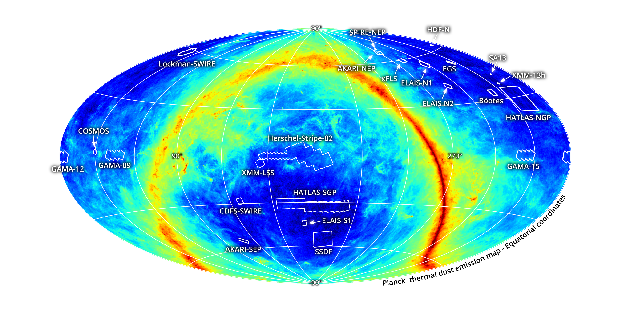
The following table lists the HELP fields with their position and size based on the SPIRE 250 maps. The name of each field is a link to a Multi Order Coverage (MOC) made from these maps. The MOC can be displayed in Aladin or used in Topcat to filter position that are inside. If you are using Python, pymoc is also very useful.
| Field (link to MOC) |
Area [sq.deg.] |
centre RA | centre Dec | RA min | RA max | Dec min | Dec max |
|---|---|---|---|---|---|---|---|
| COSMOS | 5.1 | 150.1 | 2.218 | 148.7 | 151.55 | 0.791 | 3.641 |
| GAMA-15 | 61.7 | 217.6 | 0.456 | 210.0 | 225.2 | -2.530 | 3.433 |
| XMM-LSS | 21.8 | 35.1 | -4.528 | 32.2 | 38.1 | -7.454 | -1.591 |
| Boötes | 11.4 | 218.1 | 34.173 | 215.7 | 220.6 | 32.191 | 36.109 |
| CDFS-SWIRE | 13.0 | 53.1 | -28.235 | 50.8 | 55.4 | -30.439 | -25.997 |
| ELAIS-N1 | 13.5 | 242.9 | 55.071 | 237.9 | 247.9 | 52.441 | 57.526 |
| GAMA-12 | 62.7 | 179.8 | -0.482 | 172.3 | 187.3 | -3.474 | 2.518 |
| GAMA-09 | 62.0 | 134.7 | 0.513 | 127.2 | 142.2 | -2.468 | 3.485 |
| Lockman-SWIRE | 22.4 | 161.2 | 58.058 | 154.8 | 167.7 | 55.019 | 60.819 |
| EGS | 3.6 | 215.0 | 52.720 | 212.4 | 217.5 | 51.155 | 54.234 |
| ELAIS-S1 | 9.0 | 8.8 | -43.585 | 6.4 | 11.2 | -45.523 | -41.603 |
| AKARI-NEP | 9.2 | 270.0 | 66.556 | 264.6 | 275.3 | 64.484 | 68.471 |
| ELAIS-N2 | 9.2 | 249.2 | 41.058 | 246.1 | 252.3 | 39.090 | 42.950 |
| xFLS | 7.4 | 259.0 | 59.384 | 255.6 | 262.5 | 57.917 | 60.768 |
| Herschel-Stripe-82 | 363.4 | 14.3 | -0.034 | 348.4 | 36.2 | -9.117 | 8.856 |
| NGP | 177.7 | 199.5 | 29.215 | 189.9 | 209.2 | 21.692 | 36.088 |
| SGP | 294.6 | 1.5 | -32.734 | 337.2 | 26.9 | -35.619 | -24.512 |
| AKARI-SEP | 8.7 | 70.8 | -53.862 | 66.2 | 75.4 | -55.887 | -51.682 |
| SPIRE-NEP | 0.6 | 265.0 | 69.004 | 263.7 | 266.4 | 68.553 | 69.440 |
| SSDF | 110.4 | 351.9 | -55.114 | 2.20 | 341.5 | -60.499 | -48.534 |
| HDF-N | 0.67 | 189.2 | 62.241 | 188.1 | 190.4 | 61.760 | 62.711 |
| SA13 | 0.27 | 198.0 | 42.715 | 197.6 | 198.5 | 42.407 | 43.020 |
| XMM-13hr | 0.76 | 203.6 | 37.918 | 202.9 | 204.4 | 37.379 | 38.452 |
| All HELP | 1,269 | - | - | - | - | - | - |